Archive for September 6th, 2010
Just pinging the blog…it has been a while since I updated anything. I took a pile of pictures of this creature but never managed to get a crisp shot of it flying.
Some of you know that in a former life I used to work with GPS before it was a household name.  Today just about everyone owes a GPS set.  They are in many new phones and the GPS system is just part of our modern life.  One of the first industries that really was transformed by GPS was mapping or more formally “land surveying” Wikipedia has a history of land survey.  Priory to GPS, a person would have to go out and take days to survey a plot of land.  GPS was such a time saver that some surveyors joked that GPS stood for “Getting Paid for Standing”
Doing land surveying with GPS does take special  GPS equipment to get the accuracy needed.  Also even though GPS is by its nature a “global” system a surveyor still has to take into account the local landmarks.  Just like earth has tides, the land has tides.  This means that the dirt under your feet goes up and down due to the same forces that causes the oceans to go up and down.  The amount of movement to the land is much less than that of water but this is just one of many aspects a modern surveyor has to take into account.  To accommodate for the local variance a surveyor will establish a “local” benchmark and do all the survey relative to that one point.
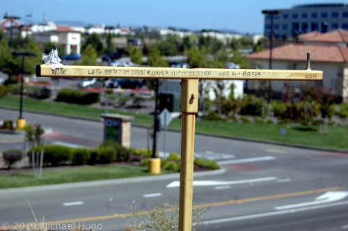
The picture below is an example of one of those points.   This one is a bit interesting in that the surveyor took the time to give the exact coordinates of the marker including altitude.  The altitude is marked as “WGS HT=88.564”.  I did not take the time verify it but that is probably NOT the actual number of meters above sea level this marker is at but rather the number of meters above the ellipsoid this marker is at.   The ellipsoid is a mathematical model for sea level. This can get complicated in hurry about exactly what what the ellipsoid is and how to convert it to the geoid on the way to get the actual height above sea level that you and I understand but I  won’t attempt it here. I won’t even bother giving a link to wiki on the subject as I’m sure I’ve bored you tears already.  As the risk of having a few tears flow I’ll mention I’m assuming it was in meters since most surveying in my time was done in meters but I might just be in feet.  If I get motivated I’ll take the time to figure out what the number really is in.
The actual antenna for the GPS receiver goes on the right side. Â Therefore the actual lat/long given is for the screw on the right side. Â The left screw is using to attach a small radio antenna that is used to send signals to the rover unit that is actually doing the surveying.


